Wow what a nice rig ...love it and I’d like to be there on this trip ..thanks for posting
You are using an out of date browser. It may not display this or other websites correctly.
You should upgrade or use an alternative browser.
You should upgrade or use an alternative browser.
Yukon-Alaska 2019
- Thread starter Rednaxs60
- Start date


Help Support Classic Goldwings:
This site may earn a commission from merchant affiliate
links, including eBay, Amazon, and others.
- Joined
- Jan 27, 2013
- Messages
- 9,855
- Reaction score
- 34
- Location
- Brisbane Australia
- My Bike Models
- 1981 GL1100 “Rats Nest”
1998 GL1500c Val
1987 CBR1000f “The Pig”
1991 CBR1000f Red
:good:  opcorn:
opcorn:- Joined
- Dec 3, 2009
- Messages
- 22,446
- Reaction score
- 265
- Location
- Van Nuys Ca.
- My Bike Models
- 1983 Interstate
2018 KLR 650
2018 BMW S1000 RR
- My Bike Logs forum link
- https://classicgoldwings.com/forums/dan-filipi.122/
Enjoying the read, Ernest!
OP
OP
Day 3 - June 26 - has come and gone. Into Dawson Creek for a few days to visit the town and enjoy the sites. Day dawned well and no rain in sight:
 However, this was to be proven wrong. The road from Hinton to Grande Cache was not bad, but as we got closer to Grande Cache the road improved. There are no amenities en route - 145 Kms - on highway 40, from Hinton to Grande Cache but the scenery is spectacular.
Grande Cache is a small town and when you enter Grande Cache on the highway there is an ESSO and FasGas, A&W, and some other restaurants:

 Do not miss this gas stop, because once you leave Grande Cache for Grande Prairie, it's 184 Kms with no gas or other amenities. The highway is very good as is the scenery. Unfortunately we hit rain for the rest of the ride into Grande Prairie with construction as well. Bike got very dirty this time.
Gas prices were quite good. $1.24/litre in Grande Cache, $1.14/litre in Grand Prairie.
Took time out in Grande Prairie to have a bite to eat at Tim's and clean the windscreen.
Road to Dawson Creek was good, scenery was nice. Stopped at Beaverlodge for a picture with the biggest beaver I've ever seen:

 Stopped for a pic at the BC border:
 Hit rain on/off for the rest of the ride into Dawson Creek, good news, road is in good condition. Got into Dawson Creek about 1600:

 Bike was very dirty so off to the car wash for a quick clean.
Going to be in Dawson Creek for a couple of days to sample the sites and stretch the pins. Bike has been working well, and the new trailer is towing well. Learning how to load it, have been experimenting as we go. A small change here and there.
Thanks for reading. Cheers
Grande Cache is a small town and when you enter Grande Cache on the highway there is an ESSO and FasGas, A&W, and some other restaurants:
Gas prices were quite good. $1.24/litre in Grande Cache, $1.14/litre in Grand Prairie.
Took time out in Grande Prairie to have a bite to eat at Tim's and clean the windscreen.
Road to Dawson Creek was good, scenery was nice. Stopped at Beaverlodge for a picture with the biggest beaver I've ever seen:
Going to be in Dawson Creek for a couple of days to sample the sites and stretch the pins. Bike has been working well, and the new trailer is towing well. Learning how to load it, have been experimenting as we go. A small change here and there.
Thanks for reading. Cheers
:clapping: Thanks for sharing..... opcorn:
opcorn:
OP
OP
Short update for Day four - 27 June. Staying at the George Dawson Inn just as you ride into town from the south. Reasonable rates, and lots of amenities. Car wash to clean your bike 2 doors down, pay by the minute. Tim's, McDs, Canadian Tire, Walmart and other restaurants very close. Downtown only 1.3 Km.
You get a breakfast and dinner chit with your room. The dinner chit is for a get one drink - second free, or $5.00 off your meal. Went in last night, Sonya had two Caesars, and I had the $5.00 off. We had soup and sandwich, and got to choose whatever sandwich was on the menu. My sandwich was a Reuban - made with roast beef - don't ask, Soya's was a Monte Cristo with cheddar cheese instead of mozza - don't ask. Both were pretty good, but the bill was outstanding. Sonya's drinks were free because we were staying at the inn, and I got $5.00 off the soup/sandwich price of $9.00. With tip - 20% - under $20.00 CDN.
Will be doing the breakfast this morning.
Two older gents came in last night so I took the opportunity to have a chat. They are on their way home to Wyoming and Utah after being on the road for some four weeks. Asked about the top of the world highway, specifically the section between Jack Wade and Chicken. They've been up here several times and have never rode this section as it is gravel, and apparently quite nasty. The border guards do not recommend touring bikes take this section on. Apparently a fellow on a GW last year tried, but had a fatal accident. Until it gets paved, won't be doing this section. Intend to ride a portion of the road to say BTDT.
Overcast day today. Hopefully no rain. Doing a walk about of Dawson Creek.
Forgot to mention that your biggest concern will be the drivers. On day 2 heading to Jasper and following a newly licensed driver (we have those stickers on the cars denoting this) crested a hill - two lane road - and saw a semi in our lane, passing on the uphill and not a lot of places to go. Quite interesting. Glad I was behind a slower driver, more time to react.
Cheers


$40.48
$45.95
Triumph Bonneville T100, T120, Bobber, Thruxton, Street Twin, Cup & Scrambler (2016 - 2017) Haynes Repair Manual (Haynes Powersport)
GoodwillBooks

$49.00
WILD HEART Waterproof Motorcycle Duffel Bag PVC500D With Rope Straps and Inner Pocket 40L 66L 100L for Kayaking, Camping, Boating,Motorcycle
ZHONGSHAN WILD FRUIT OUTDOOR


$18.99
2001 2002 2003 2004 2005 Honda GoldWing GL1800/A Service Shop Repair Manual OEM
DD_Liquidators


$100.00
$169.99
1988 Honda Gold Wing GOLDWING GL1500 Service Shop Repair Manual OEM FACTORY 88
GLAVIS ENTERPRISES

$44.95
Harley-Davidson Bar & Shield Logo Zipper Rugged Graphic Duffel Bag - Black
Wisconsin Harley-Davidson


$99.00
$129.00
Sena Universal Helmet Clamp Kit for CB/Audio of Honda Goldwing (20S, 20S EVO, 30K)
ProRidersClub


$231.99
$287.99
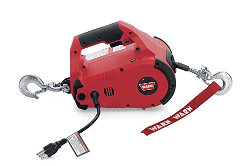
WARN 885000 PullzAll Corded 120V AC Portable Electric Winch with Steel Cable: 1/2 Ton (1,000 Lb) Pulling Capacity , Red
Amazon.com


$76.43
Honda GL 1800 Gold Wing 2001-2010 Repair Manual (Haynes Service & Repair Manual)
Chrome World

$39.95
$59.95
Honda GL1800 Gold Wing 1800 (01-10) Haynes Repair Manual (Paperback)
Haynes Repair Manuals

$38.65
$54.95
Clymer Honda GL1200, 1984-1987: Maintenance, Troubleshooting, Repair (Clymer Motorcycle)
Empty Estates

$10.19
$11.99
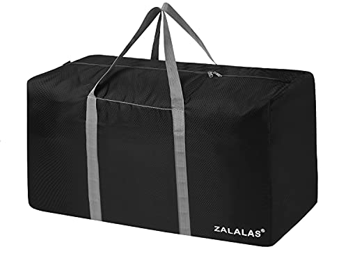
ZALALAS Travel Duffle Bag,96L Extra Large Duffel Bag Lightweight,Waterproof Duffel Bag for Men Women,Black
ZALALAS US

$150.00
1984 Honda Gold Wing GL1200 Factory Service Manual Dealer GoldWing Shop Repair Workshop
GLAVIS ENTERPRISES

$39.95
$49.95
Honda GL1500 Gold Wing Motorcycle (1993-2000) Service Repair Manual
Haynes Repair Manuals


OP
OP
Day 4 - June 27 - started off good as I mentioned in my other post. Sonya was mentioning that when she was booking our hotel, that closer to Mile "0", the more expensive the hotels. It's only about 1.3 Km to the Mile "0" and prices were about $60.00 more. Just a thought for those of you travelling.
Some of the pics are not so good, but photo work is not my forte so to speak, but trying.
Mile Zero:

 Tried a selfie:

The local museum:
 and some old equip out front:

We spent the day walking and seeing the historic sites. It has a rich past. Worker's memorial:
 There is a good local museum and exhibit about the making of the highway. If you are going to spend extra time in Dawson Creek, only need one day to see everything. One good place to go to is Stuie's Diner - good coconut cream pie.
Lots of murals to be seen as well.


Now the bad news - rain and then more rain - got soaked, and getting tired of it. End of rant.
Thanks for reading/looking. Cheers
Some of the pics are not so good, but photo work is not my forte so to speak, but trying.
Mile Zero:
The local museum:
We spent the day walking and seeing the historic sites. It has a rich past. Worker's memorial:
Lots of murals to be seen as well.
Now the bad news - rain and then more rain - got soaked, and getting tired of it. End of rant.
Thanks for reading/looking. Cheers
Great pics love it
OP
OP
Going to look into a new windshield. The OEM is too tall, and riding in the rain is a bear. Looking at the Madstad. Haven't had to concern myself with this up to now.
Cheers
Cheers
grand rouge
Member
[url=https://classicgoldwings.com/forum/viewtopic.php?p=210560#p210560:2s7jmwrv said:Rednaxs60 » June 28th, 2019, 3:39 pm[/url]":2s7jmwrv]
Going to look into a new windshield. The OEM is too tall, and riding in the rain is a bear. Looking at the Madstad. Haven't had to concern myself with this up to now.
Cheers
Ernest, what a treat to be able to er...re -ide along....just a bit.... on this adventure with you and with Sonya and your beautiful 1500 and rig. Fantastic. You are perhaps one of the very few guys able to turn a few hundred words into as many pictures. Thank you.
Windscreen...and I am figuring you have contemplated this... you might do it....or not...but....masking tape, a sharpie (or similar marker) and a 'saws all' could be yer friend here.
Flash and Big Red are enjoying this thread a lot as well. Thank you. Best regards.
Dallas
OP
OP
Day 6 - June 29 - Leaving Dawson Creek for Fort St John and started with no rain, but this didn't last long. We were going to have the wet weather gear on leaving Dawson Creek, but hedged our bets. Wouldn't have hurt Mother Nature to cooperate for once.
Coming into Taylor there is a rather long bridge that is grated for the entire length. Not a pleasant experience so for those coming north and doing the Alaska highway, be it known that this bridge exists.
Drove directly to the WAC Bennett Dam. Started raining just as we got there. We had some time to waste before the tour started so we did a ride over the dam:

 The dam is 9 metres wide at the top, but almost a Km wide at the base, impressive.
The info centre has several exhibits outside the info centre:


The tour was good with a film to start, bus ride down to the base of the dam and inside the dam structure, no pun intended. The tour guide was very good. First stop was the generator work area that is almost two football fields long:
 Left this area to the tailrace area where the water exits the generators and flows back out to the river:

Overall impression, quite good, well worth the detour. Asked about the comparison between the Niagara Falls and the WAC Bennett Dam. The Canadian side of the Niagara Falls generating complex has a slightly smaller generating capacity than the WAC Bennet Dam considering the Niagara Falls station was built in the early 1900s. The total generating capacity of the American and Canadian at Niagara Falls is more than twice that of the WAC Bennett Dam.
Left the WAC Bennett Dam under cloudy skies, and headed to Fort St John for the evening, but detoured to have a view of the unpopular Site C Dam. Going to be quite the complex when finished:

Good day all round. Cheers
Coming into Taylor there is a rather long bridge that is grated for the entire length. Not a pleasant experience so for those coming north and doing the Alaska highway, be it known that this bridge exists.
Drove directly to the WAC Bennett Dam. Started raining just as we got there. We had some time to waste before the tour started so we did a ride over the dam:
The info centre has several exhibits outside the info centre:
The tour was good with a film to start, bus ride down to the base of the dam and inside the dam structure, no pun intended. The tour guide was very good. First stop was the generator work area that is almost two football fields long:
Overall impression, quite good, well worth the detour. Asked about the comparison between the Niagara Falls and the WAC Bennett Dam. The Canadian side of the Niagara Falls generating complex has a slightly smaller generating capacity than the WAC Bennet Dam considering the Niagara Falls station was built in the early 1900s. The total generating capacity of the American and Canadian at Niagara Falls is more than twice that of the WAC Bennett Dam.
Left the WAC Bennett Dam under cloudy skies, and headed to Fort St John for the evening, but detoured to have a view of the unpopular Site C Dam. Going to be quite the complex when finished:
Good day all round. Cheers
Wow nice pics ..quite big log roller
- Joined
- Dec 3, 2009
- Messages
- 11,031
- Reaction score
- 299
- Location
- Kingsport, Tennessee
- My Bike Models
- Former '82 GL1100 "The Slug"
The tour was good with a film to start, bus ride down to the base of the dam and inside the dam structure, no pun intended.
:smilie_happy:
OP
OP
The rollers are for the conveyor belt to transport the stone/gravel used to construct the dam. The amount of gravel used could build a wall 4 metres wide and 3 metres high from Vancouver BC to Fairbanks Alaska. We should do this to compete with the great wall of China!! :music: :music:[url=https://www.classicgoldwings.com/forum/viewtopic.php?p=210624#p210624:26y6ux6r said:joedrum » Today, 1:25 am[/url]":26y6ux6r]
Wow nice pics ..quite big log roller
OP
OP
Quick update to yesterdays post. Roads are continuing to be quite good. Gas is available at appropriate distances, most GWs will never have to worry about fuel. Paid $1.61/litre yesterday between Fort St John and Fort Nelson, only gas station there so it's supply and demand. Cheers
- Joined
- Jan 27, 2013
- Messages
- 9,855
- Reaction score
- 34
- Location
- Brisbane Australia
- My Bike Models
- 1981 GL1100 “Rats Nest”
1998 GL1500c Val
1987 CBR1000f “The Pig”
1991 CBR1000f Red
:good: opcorn:
opcorn:
OP
OP
Day 7 - June 30 - started off and ended well. No rain, just a pleasant ride up the highway. Stopped for gas as I mentioned in a previous post and paid $1.61/litre - sort of reminds me of gas prices in Victoria. Stopped for a butt break at what was once a gas station/stop:
 The road is in great shape so no issues there, but it is one lonely road. I've nicknamed it the "Energizer Bunny Route" - keeps going and going and going.........
Got into Fort Nelson about 1400, gassed up, went to visitor centre and the local museum. Fort Nelson was a Hudson Bay post, and over the many years was moved 5 times to where it is now. The now is because of the highway.
The museum has lots of old, interesting stuff. Old cars, bikes, road and farming equipment. Here are a few pics of the museum site:


Cheers
Got into Fort Nelson about 1400, gassed up, went to visitor centre and the local museum. Fort Nelson was a Hudson Bay post, and over the many years was moved 5 times to where it is now. The now is because of the highway.
The museum has lots of old, interesting stuff. Old cars, bikes, road and farming equipment. Here are a few pics of the museum site:
Cheers
OP
OP
Day 8 - 1 July - HAPPY CANADA DAY!!!!! :music: :music:
Another gorgeous day in the north of Canada:
 Started off slow, but had a good ride to the North West Territory border, our outing for the day The Liard Highway is another road that keeps going and going and going...... Good road to the border but do not know about the rest to Fort Liard. There is nothing on this road so ride/take it being prepared to either turn around at the border or travel on to Fort Liard. Saw some wildlife, a small black bear, otherwise the signs are not telling the truth. Entering and leaving the NWT:


Came back to Fort Nelson and took some pics for posterity of where you enter Fort Nelson on the highway:


There is a small park just after you enter Fort Nelson, it's the Millennium Park:

Nice little hamlet for an overnight stop. Has a Tim's. Off to Watson Lake tomorrow.
Cheers
Another gorgeous day in the north of Canada:
Came back to Fort Nelson and took some pics for posterity of where you enter Fort Nelson on the highway:
There is a small park just after you enter Fort Nelson, it's the Millennium Park:
Nice little hamlet for an overnight stop. Has a Tim's. Off to Watson Lake tomorrow.
Cheers
- Joined
- Jan 27, 2013
- Messages
- 9,855
- Reaction score
- 34
- Location
- Brisbane Australia
- My Bike Models
- 1981 GL1100 “Rats Nest”
1998 GL1500c Val
1987 CBR1000f “The Pig”
1991 CBR1000f Red
Looking like an excellent time and great to see the Sunshine. :good:
Thank You for sharing.
It refreshes my memory of that ride.
The 10 miles toward the Alaska border are the worst we came across on our ride. Since there is nothing thru there- The Canadian side does not have this road on a high priority for repairs.
You can get thru it. ENJOY YOUR SELVES !!!!
A bike is allowed to go to the front of the line at construction sites. Easier for bikes to follow the lead vehicle.